Layer Options and Meanings |

|

|
|
Layer Options and Meanings |
|
|
Layer Options and Meanings |
|
|
|
Layer Options and Meanings |
|
|
In SnapMaps a variety of layers can be turned on and off. Each layer provides a different piece of information. Multiple layers can be active at one time. The images will be stacked on top of each other in a specific order: the first active layer in the list will be drawn on the bottom, then the next one on the list drawn on top of it, and so on. For example, if you have "Aerial" and "5 ft Contours" both checked, the contours will be drawn on top of the aerial image. Many of the layers are semi-transparent so that they may be used together.
The Layers sidebar is used to toggle the visibility of each layer. The layer side bar can be resized by dragging its edge or corner. Check a box to display that layer. If you want to turn on all of the layers in a section, check the Turn on/off all checkbox next to the layer title. To turn them all off uncheck the box. You may have to click this twice to get the result you desire.You can use the ![]() or
or ![]() buttons to collapse the sidebar.
buttons to collapse the sidebar.
Each layer also has an opacity slider ![]() that controls its transparency.
that controls its transparency.
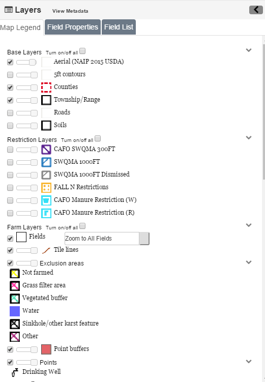
•Aerial: Aerial map with high quality color photos of the state up to around the 50ft scale. This layer is from an external source. At times this source may not load correctly, and instead of the aerial map, nothing or a checkerboard pattern may be loaded. This is usually temporary, and may not affect all scales. Zoom in to see if the layer loads properly, otherwise simply turn the layer off.
•5ft Contours: At the 2000ft scale and above this layer shows the terrain shading. At scales smaller than 2000ft this layer shows the 5ft contours. See Using the 5ft Contours for more information.
•Counties: Highlights the county borders in a dashed red line. In the middle a label with the county name is drawn.
•Township and Range: At the 5000ft scale and below this layer highlights the borders of each township in black. In the middle a label with the range, direction, and section is drawn.
•Roads: Overlays road information on the map, including the Aerial layer. When zoomed out, only major roads can be seen. Zoom in to see local roads. Note: Sometimes the road labels can be covered by the Layers sidebar or other on screen elements.
•Soils: At the 1000ft scale and below this layer highlights soil borders and displays the soil's "map unit". Sometimes this label can be hard to find; use the Identify Soil Tool to quickly find it. See Using the Identify Soil Tool for more information.
•Winter Restriction if Slope > 9%: At the 2000ft scale and below this layer covers slopes with an incline between 6% and 12% in a transparent pink. Use the 5ft Contour layer to identify slope direction.
•No Winter App. Slope > 12%: At the 2000ft scale and below this layer covers slopes with an incline greater than 12% in an transparent red. Use the 5ft Contour layer to identify slope direction.
•590 SWQMA 300ft: At the 2000ft scale and below this layer will surround perennial streams, in a 300ft radius, with diagonal blue lines going from upper left to lower right. If your farm is a CAFO then intermittent streams will also be surrounded within 300ft.
•SWQMA 1000ft: At the 2000ft scale and below this layer surrounds waterbodies (lakes and ponds), in a 1000ft radius, with diagonal blue lines going from upper right to lower left.
•Fall N Restrictions: At the 2000ft scale and below this layer will cover soils which have a fall N restriction in goldenrod dots.
•CAFO Manure Restriction (W): This layer is only an option for CAFO farms. At the 2000ft scale and below this layer covers soils which have a W restriction (soil may have bedrock within 24 inches of soil surface) with cyan W's.
•CAFO Manure Restrictions (R): This layer is only an option for CAFO farms. At the 2000ft scale and below this layer covers soils which have an R restriction (soil may have water table within 24 inches of soil surface) with cyan R's.
•Fields: This layer shows the geometry of the fields with black lines with a white border.
•Point Buffers: This layer surrounds point features in their effect radius with a transparent red.
•Points: This layer displays the icons shown in the Layers sidebar on each corresponding point.
•Exclusion Areas: This layer displays the different types of exclusion areas shown in the Layers sidebar on each corresponding point.
•DNR Wetland: At the 2000ft scale and below this layer covers the DNR Wetland areas in a transparent yellow-green.
•Perennial Streams: At the 5000ft scale and below this layer highlights perennial streams in blue.
•Intermittent Streams: At the 5000ft scale and below this layer highlights intermittent streams in a dashed blue line.
•Water-bodies: At the 5000ft scale and below this layer covers lakes and ponds in blue.
•HUC 8 Basins: Shows the HUC 8 basins with a dotted pink line. The names of the HUC 8 watersheds are also a black with pink outline.
•HUC 12 Watershed: Shows the HUC 12 watershed with a dotted aqua line. The names of the HUC 12 watersheds are also a black with aqua outline.
•Impaired Waters (303d): At the 2mile scale and below this layer shoes the 2016 DNR impaired waters..
•Outstanding/Exceptional Waters: At the 2mile scale and below this layer shoes the 2016 DNR outstanding /exceptional waters.
•Concentrated Flow Channels: This layer displays the different types of concentrated flow channels shown in the Layers sidebar on each corresponding point.
•Well Compensation: This layer shows the well compensation areas.
•Community Wells 1000ft: This layer is a 1000ft buffer around community wells with a transparent red.
•Shallow Silurian: This layer displays the areas where shallow Silurian is present.
•Bedrock Depth <5ft: This layer displays the areas where the bedrock is less than 5 feet.
•No Manure Spreading: This layer shows where no manure may be spread.
•Incorporate Only: This layer shoes where manure should be incorporated only.
•No Winter App. Slope > 6%: At the 2000ft scale and below this layer covers slopes with an incline greater than 6% in an transparent red. Use the 5ft Contour layer to identify slope direction.
•Bedrock Depth <5ft: This layer displays the areas where the bedrock is less than 5 feet.
•Channelized Flow 200ft Buffer: Setback for solid and emergency liquid manure applications. Set back requirement is in effect where the buffer area is upslope of the flow channel.
•Direct Conduit to Ground Water 300ft: Setback for solid and emergency liquid manure applications. Set back requirement is in effect where the buffer area is upslope of the conduit to groundwater.
•Wetland 200ft Buffer: Setback for solid and emergency liquid manure applications. Set back requirement is in effect where the buffer area is upslope of wetland.
•Headland Stacks: Location of manure stacking sites.