How to Access and Use Maps from Manure Management Advisory System |

|

|
|
How to Access and Use Maps from Manure Management Advisory System |
|
|
How to Access and Use Maps from Manure Management Advisory System |
|
|
|
How to Access and Use Maps from Manure Management Advisory System |
|
|
Note: The new SnapMaps website contains the latest data and will be available going forward. The 590 GeoPDFs and DATCP Interactive maps are no longer being maintained, and may not work in your browser. We have included this information in case you need to access data from these earlier systems to move into SnapMaps.
Accessing WI 590 Nutrient and Manure Application Restriction Maps on the Web
On-farm nutrient management begins with a good understanding of field-specific soils and their ability to accept nutrients and manure for optimal crop production while protecting water quality. Nutrient and Manure Application Restriction Maps show where, when, and how much manure can be applied within Wisconsin state rules (2005 Wisconsin NRCS 590 Nutrient Management Practice Standard).
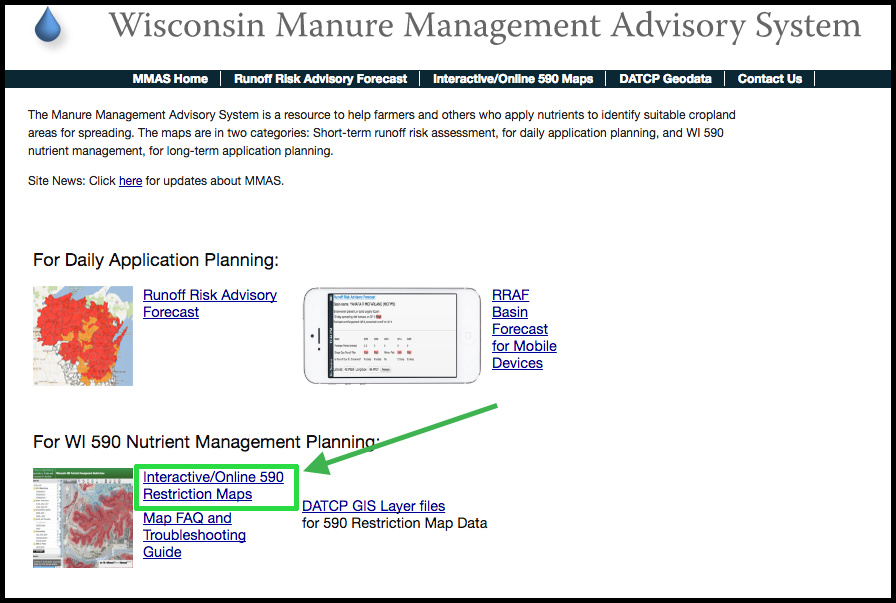
These maps are available for free on-line for the entire state for use by planners, producers, and manure applicators. You can directly access the page and download maps by going to the Help menu and selecting 590 Restriction Maps or you can connect to the website via http://www.manureadvisorysystem.wi.gov.
SnapPlus Version 1 users accessed the "590 Nutrient Application Restriction Maps" link to download GeoPDF® files; these files are no longer available.
The 590 Nutrient Management Practice restriction areas identified on the maps are:
•Soil mapping units with slope restrictions; C slopes are labeled as Winter Restrictions (if slope > 9%); D+ slopes are labeled as No Winter Application (slope > 12%)
•Soil mapping units with nitrogen application restrictions (labeled as Fall N Restrictions)
•Surface Water Quality Management Areas (300 ft from perennial streams, 1000 ft from lakes/ponds) are labeled as SWQMA (No Winter Application, Other Non-Winter Restrictions)
•CAFO plans under NR243 can use CAFO-specific Surface Water Quality Management Areas and Fall N Restrictions
Getting the Maps
1.Go to http://www.manureadvisorysystem.wi.gov. Click the Interactive/Online 590 Restriction Maps link.
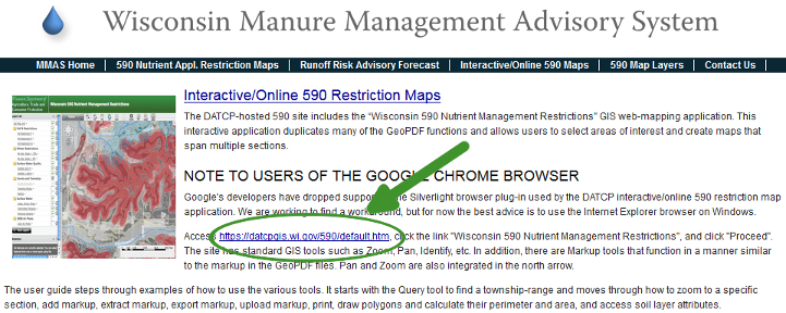
2.On the page which appears, click the link (https://datcpgis.wi.gov/590/default.htm) to go to DATCP's site.
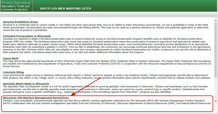
3.Scroll down to Wisconsin 590 Nutrient Management Restrictions and click that link.
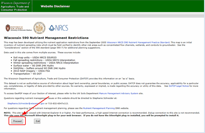
4.On the page which appears, read the disclaimer. Click on the Proceed button.
| 5. | If necessary, install the Microsoft® Silverlight® plugin in your browser; press the browser's Back button to return to GeoCortex viewer for Silverlight. Refresh the page if necessary. Note: Google Chrome no longer supports Sliverlight. Please use a different browser to access this service. |
| 6. | You should now see a page topped by a green bar labeled Wisconsin 590 Nutrient Management Restrictions. Below should be a map of Wisconsin counties. |
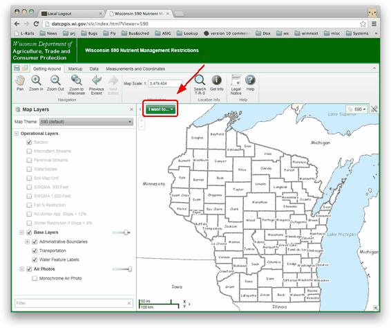
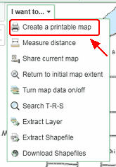
•Click the green I want to... drop-down to perform operations on the map.
•Click the Help button for detailed information on using the mapping application.
•After you zoom in to the appropriate extent and turn on the layers that you need, a map like this will be displayed:
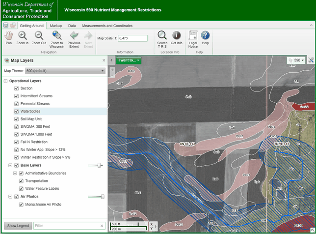
•CAFO operators creating plans under NR243 can make use of CAFO-specific map layers using the Map Theme drop-down.
•When your map is finished, you can download it as a PDF file (I want to... | Create a Printable Map) for inclusion in your nutrient management plan.
Restriction Map Specifications:
•When printed, each individual map covers the area visible in the Web application, or a map at that same scale.
•Maps contain several layers that users can turn on or off. The layers turned on are included in the printable map.
| o | NAIP Ortho-photo |
| o | 24K Hydrography, including Lakes/ponds, perennial streams, intermittent streams, Surface Water Quality Management Areas (SWQMAs) for those water features |
| o | Soil survey mapping unit boundaries, including Nitrogen restricted and slope restricted soil types |
| o | Fall N restrictions |
| o | Winter slope restrictions |
| o | Administrative boundaries |
| o | Transportation |
| o | Water feature labels |