SnapMaps Fields Tab |

|

|
|
SnapMaps Fields Tab |
|
|
SnapMaps Fields Tab |
|
|
|
SnapMaps Fields Tab |
|
|
The SnapMap Fields tab displays general information gathered about the field. This is where you can import the field data. See Importing Data into SnapPlus for more information. The Exists column specifies if the given field exists in SnapPlus or not. Once a field is imported this column will read Yes. The Field Borders column stores the polygon data for each field. If this column is populated for a given field, geometry exists for that field. Clicking Upload will send this geometry to SnapMaps, overwriting whatever is there currently. If no value exists, pressing Upload will remove whatever geometry exists in SnapMaps.
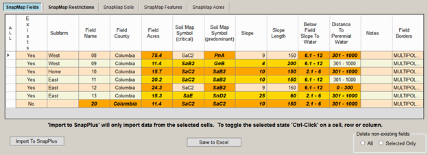
The Delete non-existing fields radio buttons are used to remove downloaded fields. When All is clicked every field which does not exist in SnapPlus will be removed. When Selected Only is pressed, fields which are selected and do not exist in SnapPlus will be removed. Once a field is removed, you can click on the Upload button to update SnapMaps to remove the field on the website.
Selecting and De-selecting cells for import
Save a snapshot of your data before you import the map data.
If you’ve hand entered the field slope and field slope length values on the fields screen - entered values different from the defaults - those values should not show up as orange on the SnapMaps Fields tab and will not get overwritten when you Import To SnapPlus.
When you click on the Import To SnapPlus button, the orange cell data will overwrite the data on the fields tab.
If you don’t want to import data in a cell you can press the Ctrl key on your keyboard and click the mouse in that cell de-selecting it. You can also Ctrl-Click on a row or column header cell to de-select all of the cells in that row or column.
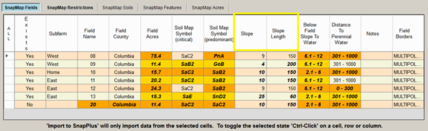
In the image below, I Ctrl-Clicked on the Slope and Slope Length columns de-selecting all of the cells in both columns. Ctrl-Click again to toggle them selected again.
•Exists: Specifies whether field exists or not, or is inactive in the field tab. •Subfarm: The subfarm the field belongs to if applicable. •Field Name: The name of the field as defined in SnapPlus or the SnapMaps website. •Field County: The county where the field is drawn. This may not match a county specified in the Farm tab, preventing the field from being imported. •Field Acres: The size of the field. This will match the data in the SnapPlus if the field has not been drawn on the SnapMaps site. •Soil Map Symbol (critical): The soil map symbol of the critical soil in SnapMaps. This will match the data in SnapPlus if the field has not been drawn on the SnapPlus site. •Soil Map Symbol (pre-dominant): The soil map symbol of the pre-dominant soil in SnapMaps. This will match the data in SnapPlus if the field has not been drawn on the SnapPlus site. •Slope: The slope of the field as defined by the soils in the field. This will match the data in SnapPlus if the field has not been drawn on the SnapPlus site. •Slope Length: The slope length of the field as defined by the soils in the field. This will match the data in SnapPlus if the field has not been drawn on the SnapPlus site. •Below Field Slope To Water: The distance to water down slope from the field. •Distance To Perennial Water: The down slope distance to perennial water from the field. •Notes: Additional information about the field. This may be filled in by SnapPlus or by you. •Field Borders: The geometry data for this field. |