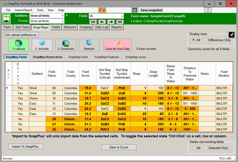
• The Upload button sends your farm data to the website. If a field has a polygon it will appear on the map, otherwise its name will appear in the names dropdown. This must be clicked when a farm is created in order to connect the farm with the website. Note: If you have made changes on the website without pressing Download, clicking Upload will wipe those changes out. The Upload button sends your farm data to the website. If a field has a polygon it will appear on the map, otherwise its name will appear in the names dropdown. This must be clicked when a farm is created in order to connect the farm with the website. Note: If you have made changes on the website without pressing Download, clicking Upload will wipe those changes out.
• The Website button opens the SnapMaps website in your default browser. The Upload button must be pressed before the website will work correctly. Note: SnapMaps does not work with Internet Explorer 9 or earlier. The Website button opens the SnapMaps website in your default browser. The Upload button must be pressed before the website will work correctly. Note: SnapMaps does not work with Internet Explorer 9 or earlier.
• The Download button retrieves the field data from the website. This will be highlighted in green when changes have been made on the website. Note: This can take a long time if there are a lot of fields. The Download button retrieves the field data from the website. This will be highlighted in green when changes have been made on the website. Note: This can take a long time if there are a lot of fields.
• The Refresh button highlights/selects the differences between the SnapMaps data and the data in your Fields subtab in the grid. If a cell is different it will be orange when selected instead of blue. To quickly import any new changes, press this button and then the Import To SnapPlus button The Refresh button highlights/selects the differences between the SnapMaps data and the data in your Fields subtab in the grid. If a cell is different it will be orange when selected instead of blue. To quickly import any new changes, press this button and then the Import To SnapPlus button • The Clear My Web Data button will remove all of your data from the SnapMap website until you upload it again. This wil not affect your desktop data. The Clear My Web Data button will remove all of your data from the SnapMap website until you upload it again. This wil not affect your desktop data.
• Imports any selected cells into SnapPlus. Imports any selected cells into SnapPlus. • Select the Crop Year data you’d like to include when you upload your field data to the web. These data will then be available on the Snap Maps website for display. Select the Crop Year data you’d like to include when you upload your field data to the web. These data will then be available on the Snap Maps website for display.
•  The SnapMap tabs switch between the SnapMaps sub-tabs. The SnapMap tabs switch between the SnapMaps sub-tabs.
• The Display Rows radio buttons switch the grid between displaying all of the fields, or just those which have data which is different than that in SnapPlus. The Display Rows radio buttons switch the grid between displaying all of the fields, or just those which have data which is different than that in SnapPlus.
• The Delete non-existing fields radio buttons delete either all or those of the currently selected fields which do not exist in SnapPlus (meaning they were created on the website and have not been imported). The Delete non-existing fields radio buttons delete either all or those of the currently selected fields which do not exist in SnapPlus (meaning they were created on the website and have not been imported). • Save the grid data to an Excel file. Save the grid data to an Excel file.
• The Pin button is used to toggle the SnapMaps tab from being a tab in the Field screen and being a separate window. See Unpinning the SnapMaps Tab for more information. The Pin button is used to toggle the SnapMaps tab from being a tab in the Field screen and being a separate window. See Unpinning the SnapMaps Tab for more information.
|